Wednesday, October 5, 2016

Colma, The Town of The Dead

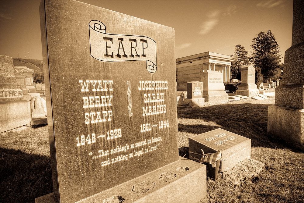
South of San Francisco, near Daly City, lies the small town of Colma where the dead outnumbers the living by a thousand to one. It’s less than 2 square miles in size, but crammed within it are as many as 17 cemeteries where rest the bodies of more than 1.5 million souls.

Nearly all of the dead were once proud residents of San Francisco, both during their lifetime and after. But at the turn of the last century, the city passed an ordinance that banished all dead from within city limits. The government argued that cemeteries spread disease, but the true motive for the eviction was the rising value of real estate —land in San Francisco was too precious to waste on dead people.


Hundreds of thousands of dead bodies were dug up and transported to vacant lands south of the city and the town of Colma began to take shape. For the better part of the century, Colma’s residents were mainly gravediggers, flower growers and monument makers. It was only after the 1980s, that other types of people and businesses began settling next to the dead. Today, the little
town has many thriving businesses, including car dealerships and shopping centers. In recent years, Colma has held many boxing events.
The history of Colma actually goes back to the middle of the 19th century, and begins with the California gold rush of 1849. The lure of quick riches brought hundred of thousands of prospectors, merchants and other immigrants from all over the world to California. Tens of thousands ended up in San Francisco. But gold seeking was not an easy business. Thousands died from accidents while others succumbed to diseases such as cholera, and San Francisco, then a small settlement of about 200 residents, found itself in need for more cemeteries. More than two dozen cemeteries were established and they were nearly filled to their capacity.
Cemetery owners than started looking towards Colma, a small community of homes and small businesses along El Camino Real and the adjacent railroad line. The first cemetery, the Holy Cross, was established in 1887.


The Orange Rocks of Bay of Fires

The Bay of Fires, on the northeastern coast of Tasmania in Australia, is a large bay that extends for about 30 km from Binalong Bay in the south to Eddystone Point in the north. The bay was named by the British navigator and explorer Captain Tobias Furneaux, in 1773, when he noticed numerous fires along the coast, which led him to believe that the country was densely populated. 

Evidence of settlement by aboriginal people can still be seen along the coast.

The Bay of Fires is characterized by white beaches, blue water and huge granite blocks that are colored bright orange by lichens. Perhaps, Captain Tobias Furneaux named the bay after these fiery red rocks. Who knows?

Lichens are a combination of algae and fungus that live together in a symbiotic relationship. The algae provides food by photosynthesis, while the fungus provides a protected environment for the algae. The combined life form has properties that are very different from the properties of its component organisms. Lichens are classified by their fungal component and are given the same scientific name as the fungus species in the lichen, irrespective of what alga lives in the fungus.


The lichens responsible for the orange hue in the rocks of Bay of Fires belong to the family Hymeneliaceae. The color is contained in their thallus, which is the vegetative part of the body. Lichens are grouped by thallus type, since the thallus is usually the most visually prominent part of the lichen. But in some lichens, the thallus is difficult to distinguish. As a result many lichens remain unclassified.


Aside from lichens, there is a wealth of local wildlife to discover around the bay area, including birds, corals and the rich marine diversity that the reefs attract.


TRUE or FALSE: Siq, Petra’s Spectacular Gorge

TRUE or FALSE: Siq, Petra’s Spectacular Gorge: The ancient city of Petra, located in the heart of the mountainous desert of southern Jordan, had different approaches in the past. One po...

Siq, Petra’s Spectacular Gorge

The ancient city of Petra, located in the heart of the mountainous desert of southern Jordan, had different approaches in the past. One possible route was from the south, across the plain of Petra and around Jabal Haroun or Aaron's Mountain. Another approach was from the high plateau to the north. But modern visitors approach Petra from the east, through a narrow gorge called the Siq, that ends dramatically in front of the elaborate ruins of the “Treasury” or Al-Khazneh in Arabic.
The Siq is not really a gorge because it was not formed by water erosion but by tectonic forces that caused the sandstone mountain to split in half creating a deep, narrow pathway. Later, water from flash floods gradually rounded the sharp edges of the gorge into smooth curves.
The entrance to the Siq once contained a monumental arch, but it collapsed in 1896 following an earthquake. Only the two abutments and some hewn stones of the arch remain.


The path through the Sig meanders for 1.2 km between beautifully-colored sandstone cliffs that tower 150 meters on either side. The Siq is no more than 3 meters wide on average, but occasionally the path widens enough to allow in warm sunlight and even a tree. In other places, it becomes so narrow that one can touch both walls with arms outstretched.

Along the way are several archaeological artifacts such as ancient water aqueducts that run along the sides of the canyon and brought water down to the center of Petra. Small niches are carved out of the rock, high up the ground and can only be accessed by stairs. There are also remnants of what must have been large and impressive statues. Along the Siq are also some underground chambers, whose function is not clear. It’s thought that they housed the guards that defended the main entrance to Petra.
As one approaches the end of the Siq, a thin sliver of the Treasury comes into view through the narrow opening. Upon exiting the Siq, visitors can have full view of its jaw-dropping grandeur.


The Treasury was originally built as a mausoleum and crypt, but legend of it containing ancient riches had earned it its current name. The loot was rumored to be hidden inside a stone urn high on the second level. Local Bedouin tribes had tried to test the theory by shooting at the urn in hopes of breaking it open and spilling out the "treasure”. But the decorative urn is, in fact, solid sandstone. Its façade is now riddled with bullet holes.